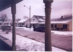
nice
Originally uploaded by pt.
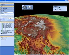
ESRI's newest viewing client, ArcGIS Explorer is reported to be prepared for release in early 2006. Users can pan,zoom, rotate (Globes), and integrate data and servies from ArcGIS clients, WMS services, and even Google Earth KMLs. Rather interesting as Google never really had any intention (as far as I have heard) of making KML a data standard, however, it appears that the likes of ESRI, FME, and others are now making KML an important data standard to be supported. More on this free 2D and 3D viewer available from ESRI at www.esri.com/software/arcgis/arcgisexplorer/index.html - posted by GISuser.com
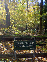
At the GCQ1RQ "Landru, Guide Us!" geocache, Boxford State Forest, Boxford/N. Andover/Middleton, MA.
So this trail was closed. In the middle of the forest. And Doug and I thought it was painfully ironic because ALL OF THE FOREST IS FREAKIN' ANIMAL HABITAT.
gah.
Didn't anyone put up trail closures where we ran into freakin' beaver dams? no. That's freakin' habitat. Flooded the trails with its habitatness.
gah.
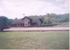
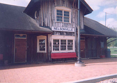
This is the train station for the Hocking Valley Scenic Railway.
A random snap I took last fall, I believe it was.

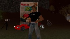
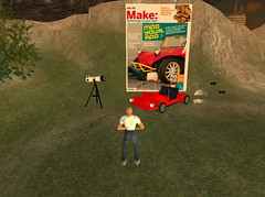
this is the cigar box guitar you can make (in real life) from make 04.
makezine.com/04/
makezine.com/04/cigarbox/
in second life, it plays the tune recorded for the online extras.
secondlife://Crescent/13/99
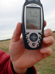
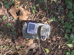
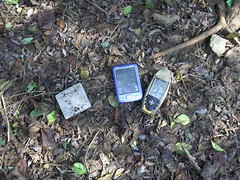
Geocaching at GCQRA6 The Rain in Maine. Never before have we had such good reception. Nine satellites at full power, except for the one that dipped just as I took the picture.
Kennebunk Plains.

First, go to www.sonyericsson.com/support, select your region, and
click the Support tab. Then, click Software Downloads and type GC82
into the search field. Click EDGE PC Card GC82. This takes you to the
support page.
Download the "Sony Ericsson Wireless Manager" and install it. It should be newer than what came in the box.
NOW you can insert the card :-)
From MAKE Photo Pool.
Check this out I visited MakeLand
--
Want to try out Second Life for yourself? Sign up at
http://secondlife.com/?u=fc5aa6a3cb3683c39348a498a6f6dfc5

I made a couple scripts that will create feeds of my newest content. I added those feeds tothe home screen, and viola... Now Playing
www.jonsthoughtsoneverything.com/2005/10/05/display-your-...
That's a big copy of Make! Nice work, Phil!
Check it out at secondlife://Crescent/13/99

Photos from Pappadopoulis Farina's visit to the Second Life Community Convention 2005.
Hurricane Information Google Map mashup
GISuser.com posted a photo:
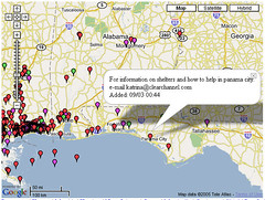
These maps are intended for the use by people affected by Hurricanes Katrina or Rita who have or are trying to find information about the status of specific locations affected by the storm and its aftermath. MAshups for Rita and Katrina are provided and users are invited to add detail. see www.scipionus.com/ - posted by GISuser.com
Sent from NewsGator Online.
GISuser.com posted a photo:
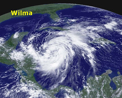
Wilma became the 12th hurricane of the 2005 Atlantic hurricane season on Tuesday over the northwestern Caribbean Sea. This season now shares the record for the most hurricanes in one season with 1969. On Monday, Wilma became the season's 21st named storm, tying the seasonal record first set in 1933. Hurricane records date back to 1851. Image credit NOAA - posted by GISuser.com
Sent from NewsGator Online.
Talll Guy has added a photo to the pool:

Here is proof that I found Who is Bill Bateman?
by scout7842
N 39° 22.765 W 076° 38.365
GCNGPV
Thanks again
Sent from NewsGator Online.
Talll Guy has added a photo to the pool:
Josh's Parking Lot
by NCPositronics
N 39° 25.257 W 076° 40.485
GCJGHJ
This cache is fun and fast. TFTC
Sent from NewsGator Online.
Talll Guy has added a photo to the pool:
The first cache I found today, and where I left the Damnit TB:
Life, the Universe, and Everything
by Indy-Md
N 39° 25.237 W 076° 40.350
GCNJ16
TFTC
Sent from NewsGator Online.
publicenergy posted a photo:

Geocaching.com has allowed use of it's data in Google Earth. More details here...
www.geocaching.com/about/google.aspx
It's amazing how many of these things are around!
Sent from NewsGator Online.
My MApping Buddy Google Map hack for Real Estate
GISuser.com posted a photo:
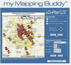
Try a demo at www.mymappingbuddy.com/demo.shtml - posted by GISuser.comI've always known that in the business world, Real Estate was going to really take hold of GIS and geospatial and run with it.. think about it.. everything about real estate is based on geography and there's likely no better use for GIS than in Real estate apps (both for the front end and the back-end). Blue Fire Group Inc. launched the myMappingBuddy The "mapping buddy" is built on the Google Map open API.
Sent from NewsGator Online.
Frapper.. another sweet Google Mashup for Social Networking
GISuser.com posted a photo:
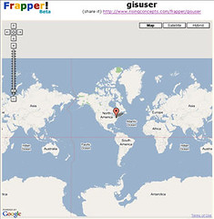
Today I stumbled onto another sweet Google mashup... Frapper
(http://www.risingconcepts.com/frapper/) What a cool mashup! The idea is
a friends + mapper site that results in a frapper group. This concept
takes social networking to a new level, enabling users to create a new
group (aka. frapper) allow people to join and then they can shout out!
Check it out, it's very cool. I've created the GISuser frapper.. feel
free to sign up and shout out. See
http://www.risingconcepts.com/frapper/gisuser
Sent from NewsGator Online.
See Rocketboom on MAKE's virtual land...
 Our favorite DIY news show, Rocketboom is now playing on MAKE's virtual land in Second Life. Andrew from Rocketboom set up a video feed so each day the video will change. We also have laser beam movies, Skype payphone video, MAKE on G4 TV and other videos to collaboratively view with other residents - enjoy. Image here and land link.
Sent from NewsGator Online.
HOW TO - video to iPod bonanza!
 Here's how to get TV from a Windows Media Center on to your video iPod, commercial-free Link. Here's how to get DVD video on your iPod with a Mac - Link. And finally, here's how to get DVD video from a Windows PC on to your video iPod - Link.
Sent from NewsGator Online.
PlaceOpedia Google mashup of the wiki
GISuser.com posted a photo:
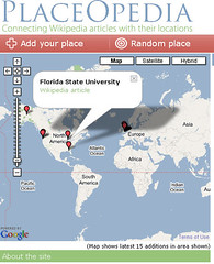
A new service called Placeopedia maps geographic locations in Wikipedia articles onto Google Maps. It's a great feature that bolsters both services and can be accessed here - www.placeopedia.com/ The map service shows the most recent 15 wiki articles listed. More details can be see at searchenginewatch.com/searchday/article.php/3555891 - posted by GISuser.com
Sent from NewsGator Online.
Subscribe to free, del.icio.us video in iTunes
Sent from NewsGator Online.
Homepages real estate site integrates mapping
GISuser.com posted a photo:
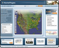
HomePagesT, the first national home buying and selling service to combine aerial maps, in-depth neighborhood information, and nationwide home listings in one integrated Web site, launched today at www.homepages.com. Free to consumers, HomePages puts aerial mapping technology to practical use by combining aerial views of neighborhoods, homes for sale, and recently sold homes with millions of data points on local communities. See www.homepages.com - this is an awesome commercial app using a dynamic map interface!
Sent from NewsGator Online.
Today's latest GISuser Geospatial & GIS news updates
GISuser.com posted a photo:
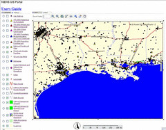
Image: The NIEHS GIS portal assembles data about contaminents, oil & gas
refineries, and other relevant data themes - see today's GISuser
spotlight feature or jump directly to
http://www-apps.niehs.nih.gov/katrina/
Wind Lake Solutions
Corporation, Maker of World's Fastest Color 3D Printers
Communications System Deployed on Florida's Gulf Coast
for Mobile Solution
International, W.I.R.E. Services / Manitoba Hydro Sign 5 year LiDAR
Services Contract
developments in GIS solutions; ESRI (UK) Tech Update events series
Uses a Lot Level Map to Access Property Information in New York City
Availability of Oracle(R) TimesTen In-Memory Database 6.0
Generation of its Japan Earthquake Catastrophe Model
Inc. Wins Top Award in World Challenge
manage Moroccan harbours
Required by the U.S. Geological Survey
Selects Geographic Technologies Group (GTG) for GIS Data Development
GeoInvent
Million Contract to Capture and Standardize 2010 Census Data
GIS & Environmental Hazard Assessment from Hurricane Katrina - To
visualize relationships, model the movement of contaminants, and
identify sources of human exposure, the NIEHS is developing an
interactive Geographic Information System (GIS). This GIS assembles maps
for Texas, Louisiana and Mississippi based on geographic, demographic,
hydrographic, infrastructure and industrial/agricultural data from
publicly accessible sources. See
http://www.gisuser.com/content/view/7089/28/
Sent from NewsGator Online.
satosphere posted a photo:
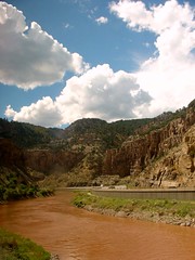
The glenwood canyon, as seen through the famed California Zephy. One of the prime examples of the ruggedness that cannot be experienced in any other mode of transportation.
The route from glenwood springs, eastward, snakes through the mountains along the glenwood canyon, formed by the colorado river. Both I-70 and the transcontinental railroad share this narrow canyon as it winds its way through the dry mountains. The railroad here literally hugs to the cliff side for most of the way through sharp turns and occasional tunnels.
Just to sample this breathtaking journey, just fire up Google Earth, turn terrain on and open this file. Play the direction to experience perhaps a part of what you actually get going in a train.
Here is a prime example of how the canyon looks: brown river, the interstate on the opposite side shelved between the river and the steep cliffs, the dry mountains topped by a breathtaking mid-day sky.
Glenwood Springs, CO
Sent from NewsGator Online.
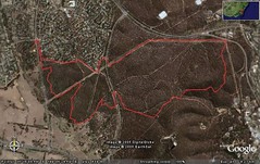
wiccked posted a photo:

The fire was in the land bordered in red. I only went to the side along the bottom so I'm not sure how far it extended "around the corner". There is a scout hut at the end of the wedge where some of the firemen were hanging around, and it did't seem to have gone into the bush to the right. There's a small creek (probably dry) there, that may have just formed enough of a break.
Sent from NewsGator Online.
Catt Family posted a photo:

As well as Flickr, notes and other stuff added directly by the user, geobloggers also trawls the API of del.icio.us and upcoming. Quietly adding that information to it's database. And because it's in the geobloggers database at can be viewed via the geobloggers main site, or queried via the API and feeds.
The locations are geocoded from just the zipcode. So you can use geobloggers to find events near you or in a specific area, just not the exact location.
Here's the Google Earth network link that'll find newest Upcoming Events...
Google Earth Upcoming
(Nearest coming soon)
Geocoding from street number, name and zipcode is too API intensive at the moment, i.e. I'd have to depend on another service from another website and geobloggers is already a web of service consumption, aggregating and feeds.
Sent from NewsGator Online.