
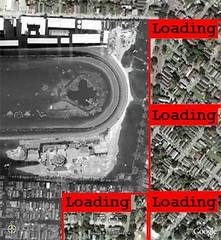
DSCF0657
Originally uploaded by scottieosu2000.
Sent from NewsGator Online.
shastrix posted a photo:
What happens when two legends get together? Awesome stuff, that leaves you goggle-eyed.
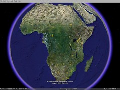
10 days back, the Google folks released their NatGeo layers; just start Google Earth and enable the NGM layers. Ashté!
Some more details.
Sent from NewsGator Online.
1900 Galveston hurricane Track
GISuser.com posted a photo:
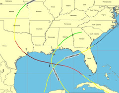
This map shows the path of the un-named hurricane that struck Galveston, Texas in 1900. It made landfall as a category 4 hurricane and was the most destructive hurricane ever in North America. Currently, Rita has measured as the 3rd stringest recorded hurricane on record and is following a very similar path. This map was derived from the NOAA historical hurricane track IMS found at hurricane.csc.noaa.gov/hurricanes/ - created and posted by www.GISuser.com
Sent from NewsGator Online.
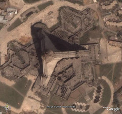
Submarines - Looks like whale families
earthhopper posted a photo:
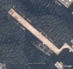
Kure Naval Port - Japan's Self-Defense Agency.
Looks like whale families.
kmz download for Google Earth
GeoTagged
Sent from NewsGator Online.
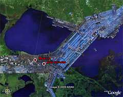
GIScorps Hurricane Katrina Maps - Mississippi
GISuser.com posted a photo:
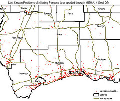
Map of last know position of missing persons generated for FEMA. Read on for a look at the response, some Q & A's, and example maps and images from the GIScorps in Mississippi. See this feature at GISuser.com - www.gisuser.com/content/view/6945/28/
Sent from NewsGator Online.
Google Maps Hurricane Rita Tracker
Google Maps Hurricane Rita Tracker - As Hurricane Rita goes back out to sea after crossing over the Florida Keys you can track her progress in the coming days with this Google Maps integration which mashes up data from FLHurricane.com and Google Maps.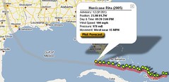
Sent from NewsGator Online.
Rita and Google Earth overlays
 DIY Weather channel - Ivo Janssen writes "I was browsing the Hurricane Rita path on the NOAA website, and then realized that Google Earth does image overlays. So I turned NOAA's boring picture into fascinating 3D views of the hurricane path. Currently, it's slated to miss Austin, make landfall at Matagorda Bay, take US-77 to Temple and Waco and then go on over Forth Worth". Link.
Sent from NewsGator Online.
Hiroshima Atomic Bomb - Devastated Land - Google Earth Overlay
earthhopper posted a photo:
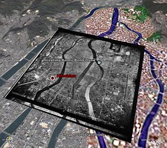
Image overlay of Hiroshima taken in 1947 by US military.
The atomic bomb hit the city on Aug 6, 1945 and killed more than 140,000 people on the day, 240,000+ listed as of now.
earthhopper.syuriken.jp/places/kmzkml/hiroshima.kmz
Sent from NewsGator Online.
Hiroshima Atomic Bomb - Devastated Land - Google Earth Overlay
earthhopper posted a photo:
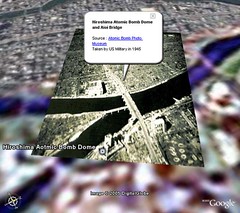
Image overlay of Hiroshima Atomic Bomb Dome, taken in 1945.
The atomic bomb hit the city on Aug 6, 1945 and killed more than 140,000 people on the day, 240,000+ listed as of now.
earthhopper.syuriken.jp/places/kmzkml/hiroshima.kmz
Sent from NewsGator Online.
Amagasaki Train Accident Site - April 25, 2005
earthhopper posted a photo:
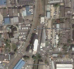
Killed 107 people and injured 555. www.forbes.com/home/feeds/afx/2005/09/06/afx2206702.html
earthhopper.syuriken.jp/places/kmzkml/amagasaki.kmz
GeoTagged
Sent from NewsGator Online.
This story was sent to you by RJBailey (Ron Bailey), from Rojo.
Rojo is a new FREE service for discovering, reading, and sharing Internet news and information. Rojo lets you view information from a wide variety of major news sources, special interest publications and the emerging world of weblogs and RSS in an easy to use digest. You can easily customize Rojo to view only the information that is of interest to you. Sign up for your FREE Rojo account!
©2005 Rojo Networks, Inc.
Radio Tower Survived - Hurricane Katrina
earthhopper posted a photo:
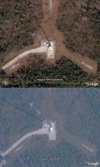
A Radio Tower survived near highway 607 in Bay St. Louis, MS.
Upper-before, lower-after.
www.googleearthhacks.com/dlfile6966/Radio-tower-survives.htm
GeoTagged
Sent from NewsGator Online.
Google Earth - NOAA Server for Katrina Satellite Images
earthhopper posted a photo:
Google Earth provide exclusive servers for Images for impacted area by Katrina.
NOAA Satellite images and ImageAmerica's aircraft images.
earth.google.com/katrina.html
Sent from NewsGator Online.
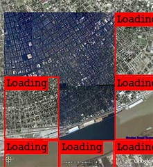
Geology.com Google Maps overlays
Sent from NewsGator Online.
Your Fortune Is |
 |
| Your Birthdate: August 29 |
 Your birthday on the 29th adds a tone of idealism to your nature. You are imaginative and creative, but rather uncomfortable in the business world. You are very aware and sensitive, with outstanding intuitive skills and analytical abilities. The 29 reduces to 11, one of the master numbers which often produces much nervous tension. This is the birthday of the dreamer rather than the doer. You do, however, work very well with people. |
Image America Tileset 09/02 for Google Earth - Levee Breach Point
earthhopper posted a photo:
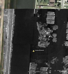
bbs.keyhole.com/ubb/showthreaded.php/Cat/0/Number/102990/...
ImageAmerica-VBR-netlink -- these images were taken on Friday 2nd Sept from Image America's low-flying aircraft. They are black and white, but the resolution is 12".
This is levee breach point in New Orleans.
Sent from NewsGator Online.
Image America Tileset 09/02 for Google Earth
earthhopper posted a photo:
bbs.keyhole.com/ubb/showthreaded.php/Cat/0/Number/102990/...
ImageAmerica-VBR-netlink -- these images were taken on Friday 2nd Sept from Image America's low-flying aircraft. They are black and white, but the resolution is 12".
Sent from NewsGator Online.
NOAA Tileset 09/01-09/05 for Google Earth
earthhopper posted a photo:
bbs.keyhole.com/ubb/showthreaded.php/Cat/0/Number/102990/...
NOAA-VBR-netlink -- this will allow you to see the entire NOAA dataset (through Sept 5th) in near-full resolution without having to download the 2Kx2K images.
Sent from NewsGator Online.
Google Maps overlayed onto Google Earth, London View
Catt Family posted a photo:

Google please do this so I don't have to host it ;)
Network link is here...
www.geobloggers.com/feeds/googleMapOverlay.kml
Blog post is here...
geobloggers.blogspot.com/2005/09/google-earth-network-lin...
Sent from NewsGator Online.
Google Map Tiles Network Linked onto Google Earth
Catt Family posted a photo:

I Rawk!!
Network link is here...
www.geobloggers.com/feeds/googleMapOverlay.kml
Blog post is here...
geobloggers.blogspot.com/2005/09/google-earth-network-lin...
Sent from NewsGator Online.
61,344 geotagged images (map61344)
Catt Family posted a photo:

This is all the geotagged photos as of last night.
If you go over here...
www.geobloggers.com/growth/
...you'll see a bunch of images showing the growth for each new 1,000 images, that's once every 2 days.
Because it saves the files a jpg and then writes the next 1,000 over the top, the first few are getting pretty crudded up by the repeated jpg compression.
When we reach 100,000 I'll make a lossless .png. I'll probably also do USA, UK and Europe ones.
What do we learn? Well outside of USA and Europe people like to take photos at the coast.
Sent from NewsGator Online.


