1900 Galveston hurricane Track
GISuser.com posted a photo:
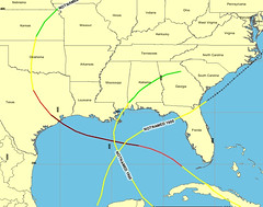
This map shows the path of the un-named hurricane that struck Galveston, Texas in 1900. It made landfall as a category 4 hurricane and was the most destructive hurricane ever in North America. Currently, Rita has measured as the 3rd stringest recorded hurricane on record and is following a very similar path. This map was derived from the NOAA historical hurricane track IMS found at hurricane.csc.noaa.gov/hurricanes/ - created and posted by www.GISuser.com
Sent from NewsGator Online.
No comments:
Post a Comment